THIS WEEK IN INTRO. TO GIS
Good Student Answer to Question #1 of Quiz #1: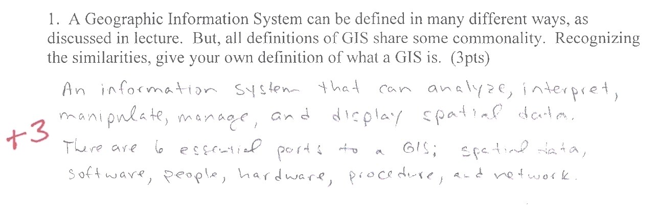
Data Acquisition
Data Sources
Spatial/Temporal Characteristics of Remote Sensing Systems
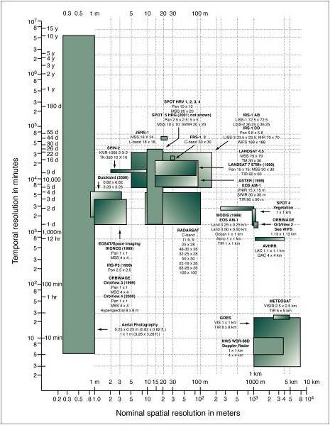
"Spatial and temporal characteristics of commonly used remote sensing systems and
their sensors" From: Geographic Information Systems and Science, 2nd ed.
Paul Longley, Michael Goodchild, David Maguire, and David Rhind. Originally From:
Jenson, J.R. and Cowen, D.C. 1999 'Remote Sensing of urban/suburban infrastructure
and socioeconomic attributes' PERS, 65, 611-622.
Views From Different Satellites
Interactive Resolution Comparison
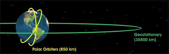 Polar Orbiting Satellites vs Geostationary Satellites
International Geostationary Systems
Polar Orbiting Satellites complete 14 orbits per day, thus
covering the entire earth twice in a 24-hour period. They pick
up the high-latitudes that are not covered by the Geostationary
satellites. Their track runs nearly North to South passing close
to both poles. They make back and forth swaths.
SPOT Satellite
LANDSAT
Bands 4-7 (.5-1.1ƛ)
What spectral bands to I use for my study?
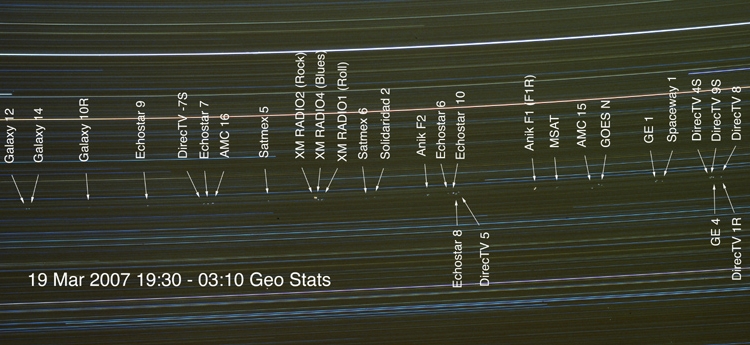 A time lapse of a small portion of the geostationary orbit taken from atop Kitt Peak in Arizona from 0230Z to 11Z on March 19, 2007. The lines represent star trails, while the bright dots mark the positions of geostationary satellites. Courtesy of Dave Dooling, National Solar Observatory. This image only accounts for 9% of all geostationary satellites orbiting Earth.
Federal Geographic Data Committee Standards [FGDC]
NATIONAL MAPPING PROGRAM STANDARDS
Error, Accuracy, and Precision
From: Geographic Information Systems and Science, 2nd ed.
Paul Longley, Michael Goodchild, David Maguire, and David Rhind.
OGC: The Open Geospatial Consortium
Data Acquisition Continued
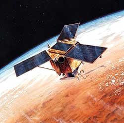
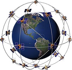
Global Positioning Systems (GPS)
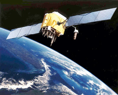
GPS Satellite
Photo from U.S. Army
Free Software for Downloading
and Working with Waypoints
COMPONENTS TO GPS
The Space Component
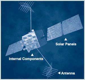
Image Source: FAA
From Garmin.com Website
|
The Space component consists of: The space segment includes the satellites and the Delta rockets that launch the satellites from Cape Canaveral, in Florida. GPS satellites fly in circular orbits at an altitude of 10,900 nautical miles (20,200 km) and with a period of 12 hours. The orbits are tilted to the earth's equator by 55 degrees to ensure coverage of polar regions. Powered by solar cells, the satellites continuously orient themselves to point their solar panels toward the sun and their antenna toward the earth. Each of the 24 satellites, positioned in 6 orbital planes, circles the earth twice a day. The satellites are composed of: Solar Panels. Each satellite is equipped with solar array panels. These panels capture energy from the sun, which provides power for the satellite throughout its life. External components such as antennas. The exterior of the GPS satellite has a variety of antennas. The signals generated by the radio transmitter are sent to GPS receivers via the L-band antennas. Another component is the radio transmitter, which generates the signal. Each of the 24 satellites transmits it's own unique code in the signal. Internal components such as atomic clocks and radio transmitters. Each satellite contains four atomic clocks. These clocks are accurate to at least a billionth of a second or a nanosecond. An atomic clock inaccuracy of 1/100th of a second would translate into a measurement (or ranging) error of 1,860 miles to the GPS receiver. |
The Control Component
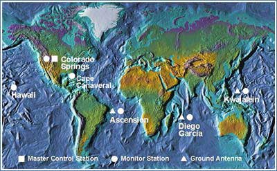
Image Source: FAA
|
The Control Segment of GPS consists of: Master Control Station: The master control station, located at Falcon Air Force Base in Colorado Springs, Colorado, is responsible for overall management of the remote monitoring and transmission sites. GPS ephemeris being a tabulation of computed positions, velocities and derived right ascension and declination of GPS satellites at specific times, replace "position" with "ephemeris" because the Master Control Station computes not only position but also velocity, right ascension and declination parameters for eventual upload to GPS satellites. Monitor Stations : Six monitor stations are located at Falcon Air Force Base in Colorado, Cape Canaveral, Florida, Hawaii, Ascension Island in the Atlantic Ocean, Diego Garcia Atoll in the Indian Ocean, and Kwajalein Island in the South Pacific Ocean. Each of the monitor stations checks the exact altitude, position, speed, and overall health of the orbiting satellites. The control segment uses measurements collected by the monitor stations to predict the behavior of each satellite's orbit and clock. The prediction data is up-linked, or transmitted, to the satellites for transmission back to the users. The control segment also ensures that the GPS satellite orbits and clocks remain within acceptable limits. A station can track up to 11 satellites at a time. This "check-up" is performed twice a day, by each station, as the satellites complete their journeys around the earth. Noted variations, such as those caused by the gravity of the moon, sun and the pressure of solar radiation, are passed along to the master control station. Ground Antennas: Ground antennas monitor and track the satellites from horizon to horizon. They also transmit correction information to individual satellites. |
The User Component
|
The user component consists of: The user segment includes the equipment of the military personnel and civilians who receive GPS signals. Military GPS user equipment has been integrated into fighters, bombers, tankers, helicopters, ships, submarines, tanks, jeeps, and soldiers' equipment. In addition to basic navigation activities, military applications of GPS include target designation, close air support, "smart" weapons, and rendezvous. With more than 500,000 GPS receivers, the civilian community has its own large and diverse user segment. Surveyors use GPS to save time over standard survey methods. GPS is used by aircraft and ships for enroute navigation and for airport or harbor approaches. GPS tracking systems are used to route and monitor delivery vans and emergency vehicles. In a method called precision farming, GPS is used to monitor and control the application of agricultural fertilizer and pesticides. GPS is available as an in-car navigation aid and is used by hikers and hunters. GPS is also used on the Space Shuttle. Because the GPS user does not need to communicate with the satellite, GPS can serve an unlimited number of users. The aviation community is using GPS extensively. Aviation navigators, equipped with GPS receivers, use satellites as precise reference points to trilaterate the aircraft's position anywhere on or near the earth. GPS is already providing benefits to aviation users, but relative to its potential, these benefits are just the beginning. The foreseen contributions of GPS to aviation promise to be revolutionary. With air travel nearly doubled in the 21st Century, GPS can provide a cornerstone of the future air traffic management (ATM) system that will maintain high levels of safety, while reducing delays and increasing airway capacity. To promote this future ATM system, the FAA's objective is to establish and maintain a satellite-based navigation capability for all phases of flight.
|
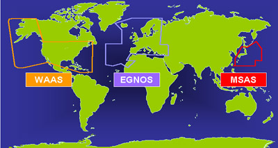
WAAS Near-Real-Time Coverage Map
Probation Officers Keep Tabs With GPS
UPCOMING EVENTS
Take Home Exercise (THX) #5
Due: Check With Instructor
Take Home Exercise (THX) #4
Past Due: September 18
Readings in Longley Text
Chapter 9: GIS Data Collection
Chapter 6: Uncertainty
Chapter 5: Georeferencing
CLASS RESOURCES
Lab Exercises
Lab Exercise # 3
Cal-Fire website link broken
as of FALL 2014
Use the following temporary link to access
the Fire Hazard Severity Zones
How Should I Study
for Quizzes?
Free Software for Downloading
and Working with Waypoints
Watch the:
History
of GIS
Video
Geospatial Revolution: History of GIS. Downloaded from Teachers' Domain. © 2010 the Pennsylvania State University. All rights reserved. Materials courtesy of Pennsylvania State University. CC Version.
2004 Presidential Election
Data Results as seen on
CBS News on Election Night
(1st Use of GIS for this Purpose)
Commercial GIS Example:
DigitalGlobe
Online GIS Data Resources
STARTING THE HUNT
FOR GIS DATA
San Diego
Association of Governments
SANDAG
U.S. Census Bureau
Cartographic Boundary Files
Web-based GIS Projects
SDSU Web Based GIS of Wildfires
Utah Water Science Center
Web-based GIS
FEMA
Mapping Information Platform
U.S. Census Bureau
FactFinder Mapping Interface
California Digital
Conservation Atlas
Other Useful Links
How to Calculate the Area
of a Polygon Feature in
a Shapefile

8800 Grossmont College Drive
El Cajon, California 92020
619-644-7000
Accessibility
Social Media Accounts


