1. f,c,b,i,a,d,e,g
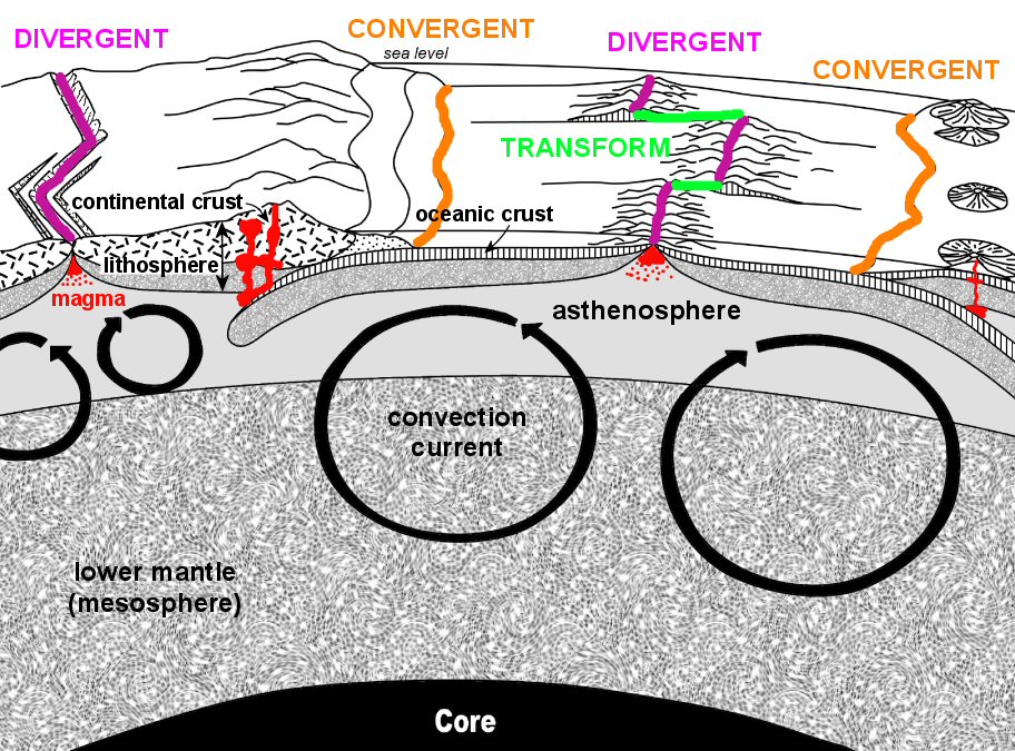
2. The lithosphere is buoyantly supported by the asthenosphere.
3. Oceanic crust is made of basalt (~50% SiO2) and is thinner but more dense than continental crust. Continental crust is compositionally quite variable, but overall it approximates the composition of granite (~70% SiO2). The thick, low density continental crust floats higher on the asthenosphere than the thin, high density oceanic crust, like a thick sheet of Styrofoam floats higher on water than a thin sheet of ice.
(2) Numerous fossil matches exist on continents that are separate today. Fossils are most similar from the time of Pangaea (200 mya). Fossils from different continents become progressively more dissimilar as their ages approach the present. The fossil record suggests that when Pangaea existed, organisms could migrate freely, but when it broke apart, migration became progressively more difficult.
(3) Numerous rock matches also exist between separated continents in places that would have been adjacent when Pangaea was intact. Like the fossil matches, the best rock matches come from rocks the same age as Pangaea. Rocks younger than Pangaea do not match well.
(4) Paleoclimates (ancient climates), as indicated from the distribution of certain climate-indicative rocks, do not match the current distribution of climates. For example: In Kenya, which is on the equator, there are ancient tillites (rocks composed of glacial debris), while rocks of the same age in Canada may include limestone and coal (formed in tropical environments). When the continents are reassembled into their Pangaea configurations these apparent climatic discrepancies become resolved. At the time of Pangaea, Kenya was positioned near the South Pole while North America was centered on the equator.
(5) Paleomagnetism (ancient magnetism) recorded in rocks of the same age as Pangaea but from different continents, apparently indicates multiple positions for the earth’s North Magnetic Pole at the same time! The physical impossibility of having the North Magnetic Pole in many different places at the same time is resolved when the continents are moved back into their Pangaea configurations. Moving a continent also moves their paleomagnetically imprinted rocks and the positions of the indicated magnetic poles. When returned to their Pangaea positions, rocks of the same age on different continents indicate the same position for the Magnetic North Pole.
5.
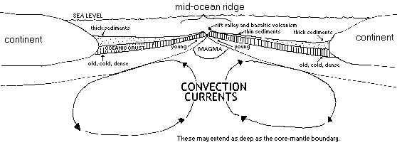
6. The mantle, heated from below and cooled from above, stirs in giant but very slow moving convection currents. These constantly bring hot mantle material up towards the earth’s surface in areas undergoing lithospheric spreading and allow cooled mantle to sink elsewhere. When the hot mantle rises, the pressure on it lowers, causing a drop in it’s melting temperature and the consequent formation of magma. Such melting occurs in the asthenosphere, generally beneath the oceanic mountain ranges known as mid-ocean ridges, but also occurs beneath areas of continental rifting. In either case, the spreading which occurs in these places thins the lithosphere, thereby reducing it’s weight and corresponding pressure on the underlying asthenosphere. The pressure drop due to lithospheric thinning accentuates the pressure drop that occurs in asthenosphere due to convection. The resultant magmas rise through the cracks caused by spreading towards the surface where they may pour out as lava. Cooling solidifies the magma and lava into the rock basalt - new oceanic crust.
Oceanic crust is destroyed by subduction. Subduction occurs when ocean crust is carried away from mid-ocean ridges by sea floor spreading, where upon it ages, cools, contracts, and becomes too dense to float on the asthenosphere. The oceanic crust (and the uppermost mantle fused to it) sinks deep into the mantle, eventually mixing with the asthenosphere and mesosphere.
7. Earthquakes occur along plate boundaries.
8.
9.
|
FEATURE/ACTIVITY |
DIVERGENT |
TRANSFORM |
C O N V E R G E N T |
||
|
|
|
|
OCEAN-OCEAN |
OCEAN-CONTINENT |
CONTINENT-CONTINENT |
|
oceanic ridge |
X |
(between ridges) |
|
|
|
|
rift valley |
X |
|
|
|
|
|
basaltic volcanism |
X |
|
only initially |
|
|
|
andesitic volcanism |
|
|
X |
X |
|
|
deep-sea trench |
|
|
X |
X |
|
|
island arc |
|
|
X |
|
|
|
volcanic arc |
|
|
|
X |
|
|
shallow earthquakes |
X |
X |
X |
X |
X |
|
deep earthquakes |
|
|
X |
X |
|
|
subduction zone |
|
|
X |
X |
|
10. 5cm/year x 1,000,000 years x 1m/100cm 1km/1000m = 50km
735km x 1my/50km = 14.7 my

8800 Grossmont College Drive
El Cajon, California 92020
619-644-7000
Accessibility
Social Media Accounts


