Skip to contentSkip to Main Site NavigationSkip to Site Left NavigationSkip to Site Utility NavigationSkip to Site SearchSkip to FooterDownload Adobe Reader
Physical Geography
Home » People » Scott Therkalsen » GEO 120: INTRODUCTION TO PHYSICAL GEOGRAPHY » REVIEW QUESTIONS FOR TEST NUMBER TWO
Print

REVIEW QUESTIONS FOR TEST NUMBER TWO

REVIEW QUESTIONS FOR TEST NUMBER TWO:

Rewrite and answer all of the following questions in detail for extra credit.

AIR TEMPERATURE

1. What is heat?

2. What is temperature?

3. How do we measure temperature? How does a thermometer work?

4. Compare and contrast the three scales discussed in class (Fahrenheit, Celsius, and Kelvin)

 5. What are the conversion equations? Pick some numbers and convert from one scale to another using the formulas from class?

6. How does air temperature vary vertically? Graph the vertical temperature distribution.

  • What is the relationship between temperature and elevation in the troposphere? AND what is the reason for this relationship?
  • What is the Environmental lapse rate? Apply this to changes in elevation to explain changes in temperature.
  • What is the relationship between temperature and elevation in the stratosphere? AND why does this relationship exist?

7. How does surface temperature vary across the earth? (what are the 4 variables)

8. Explain how insolation receipt varies across the earth and how it contributes to surface temperature.

ü  What is “time lag” in reference to air temperature?

9. What is the principle of continentality? What is a temperature range?

10. What were the different characteristics of land versus water that we discussed in class that led to the principle of contenentality?

11. How is surface elevation related to surface temperature? Explain how and why a locations elevation affects its temperature.

12. Compare and Contrast San Diego and Charleston South Carolina in terms of the variables and air temperature (Hint: they have many of the same geographic characteristics with one important difference)?

13. Explain the role ocean currents play in influencing global temperature distribution.

14. What is an isotherm?

15. As a culmination of this portion refer to page 119, figure 5.20 (“Mean monthly air temperatures”) in your book to explain air temperatures in detail using all of the variables covered in class.

  • Explain the seasonal change in isotherms
  • Compare and contrast the characteristics of isotherms over water and over land (how do they “bend” seasonally and why?)
  • What is explains the isotherm action on the west coast of South America?
  • Where (in terms of latitude) is the July 25°C isotherm on the west coast of North America versus the east coast and what explains this?
  • What place in the world is coldest by far in January? Use the multiple variables to explain why.

 AIR PRESSURE AND WIND

1. What is wind?

2. What is atmospheric pressure?

3. How is atmospheric pressure measured?

4. How does atmospheric pressure vary? Graph the vertical distribution of air pressure.

ü  Explain the vertical variation of atmospheric pressure in detail.

5. Explain the difference between changes in atmospheric pressure when climbing a mountain from 0ft to 1000 ft compared with climbing a mountain from 20,000ft to 21,000ft.

6. Explaining air movement:

  • What is a pressure gradient ?
  • What is a pressure gradient force?
  • How is a pressure gradient related to wind strength?
  • How do air molecules behave in the atmosphere that is from what type of pressure to what type?

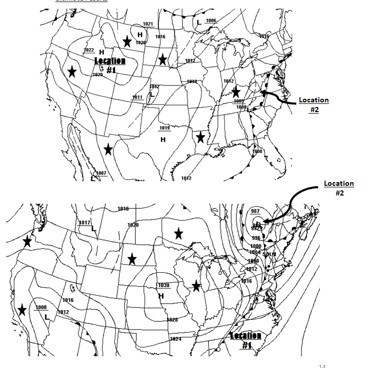
7. Explain the city 1 versus city 2 air pressure diagram from your test 2 handout.

8. Diagram and explain in detail both the sea breeze (day) and land breeze (night) wind circulation models? Why are these models important to understand?

9. What is the Coriolis force?

10. What are isobars? How do they help to determine which direction wind will be flowing?

11. What does wind look like (relative to isobars) when only considering the PGF and the Coriolis force?

12. What are geostrophic winds?

13. What is surface friction?

  • How does it affect air molecule movement?
  • How does surface friction change with height?

14. Draw and explain how air flows around systems of high pressure and systems of low pressure in the following terms

  • Names
  • Surface flow and upper atmosphere flow
  • Vertical movement
  • Resulting sky situation

15. Use a real time surface analysis map (linked through the website) to explain air movement at the surface in San Diego.

16. Explain global air circulation

  • Draw and explain the Hadley single cell model.
  • What is the driving force behind this model (Hint: the same as the cities and the sea breeze)
  • Draw and explain the 3 cell model of global circulation. Include wind direction at the surface and what is happening aloft. As well as drawing the arrows and pressure belts make sure you know the reasons behind this diagram
  • What are the names of the various pressure belts and winds? How do the winds get their names?
  •  What is the difference between dynamically generated and thermally generated pressure? At what locations do you find examples of each of these and Why?                      (continued on next page
  • What causes low pressure at the equator, high pressure at the horse latitudes, high pressure at the Poles, low pressure at 60 degrees? Explain in a complete systematic step by step manner.
  • What type of atmospheric results are found at certain latitudes as a result of the global pressure distribution?

  ATMOSPHERIC MOISTURE AND MEASURES OF HUMIDITY

1. What is atmospheric moisture? Where does it come from? AND why is it so important?

2. Explain Humidity

  • What are the different ways humidity is measured? (What is specific humidity? What is relative humidity? What is dew point temperature?)
  • How are each of these expressed/measured?
  • What does each tell us about the atmosphere?

3. What causes changes in air capacity to contain water vapor gas?

4. What does it mean when an air mass is completely saturated?

  • Explain the process of condensation.

5. Review the transfers of energy that take place as water changes state

  • Draw and explain the phase change diagram from section one

6. What happens to ________ when temperature increases?

  • Relative humidity
  • Specific humidity
  • Dew Point Temperature

9. How are clouds formed?

  • What are the most common things that water droplets condense around?

10. What is fog?

  • Explain radiation and advection fog
  • Explain why there is always a California coastal fog.

11. What characteristics are clouds classified by?

  • Sketch and apply the cloud terms to clouds present outside today and ones present on a rainy day.

ADIABATIC COOLING AND CLOUD FORMATION

1. What is the adiabatic principle?

  • How is it related to cloud formation?
  • Explain the step by step process as an air mass changes elevation?
  • Elevation, pressure, temperature, capacity, condensation or not.

2. What is the difference between the dry adiabatic lapse rate and the wet adiabatic lapse rate?

  • What are the rates?
  • In what circumstances do you use one versus the other?

3. Explain the four different lifting mechanisms.

4. What is convective lifting?

  • How do you know if an air mass will continue to rise or sink?
  • What is the lifting condensation level?

7. Diagram a convectively rising air mass (as we did in class):

  • Start with an air mass temperature of 65°F and dew point of 59.5°F and a surrounding temperature of 60°F

Show changes in the following: air mass temperature, DPT, surrounding air temperature, lapse rates used, lifting condensation level

8. What is orographic lifting? How does it apply to San Diego County?

9. Which is the windward/leeward side of a mountain? What is the rain shadow effect?

10. What is frontal lifting? What is a front?

11. How can you locate a weather front on a map?

12. What is happening along a stationary front?

13. Compare and contrast a warm front versus a cold front

  • Which air mass is moving?
  • What do the slopes look like?
  • Which moves faster?
  • What types of clouds are associated with each?
  • which brings more violent weather AND WHY?

14. What is an occluded front?

  • How does it occur?  Where are you likely to find occluded fronts?

15. What is a “Jet Stream?”

  • Where are they located?
  • Where do they form (along what type of boundaries)?
  • How do they influence surface pressure (convergence into a bend leads to _______, divergence out of a bend leads to _______ surface pressure).

14. What is an air mass?

  • Where do air masses get their characteristics from?
  • What types of places make good source regions for air masses?
  • How are air masses classified?

15. Classify different air masses by name and explain what their temperature and moisture characteristics would be:

  • One found in Siberia
  • One found in tropical Indian Ocean
  • One found in the Sahara desert

16. Where do air masses “clash?”

17. What is a mid latitude cyclone? How does it form?

18. What is a tropical cyclone? When does it form?

  • How are Hurricanes categorized?

19. What is a tornado?

  • How does it form?
  • Why is the place known as “tornado alley” more likely to have tornados than other locations (4 reasons)?
  • How are tornados categorized?

20. Compare and Contrast tropical cyclones, mid latitude cyclones and Tornados (energy sources, size, intensity, etc.)

21. Explain San Diego’s Unique weather:

  • “June Gloom”
  • “Santa Anas”
  • “Catalina Eddy”                                                                      

AS A CULMINATION COMPLETE THE FOLLOWING FOR THE 2 SURFACE ANALYSES

  • Draw large arrows to indicate the surface winds at the stared locations on the maps
  • At the numbered locations explain the forecasted weather in a step by step manner based upon this entire section of class
  • For example, wind direction/speed, is there a weather front present, a pressure system present, is air converging/diverging, is air rising/falling, and what are the ultimate results

 weather maps


Last Updated: 06/16/2015
  • GCCCD
  • Grossmont
  • Cuyamaca
A Member of the Grossmont-Cuyamaca Community College District