DUE TUESDAY MARCH 19TH, 2014 - Note: You need access to ArcGIS software to complete this exercise, ideally. Or, you can use the online ArcGIS Resource Center.
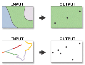
Editing features within data layers in ArcGIS can be performed by using geoprocessing (analysis) tools. A variety of different tools are available for different purposes. Each of the graphics on this page contain an input data file, a geoprocessing tool function (represented by the "arrow"), and an output data file. Using the list of geoprocessing tools, perform the following:
1. By examining the input and output data, name the geoprocessing tool used for each illustration.
2. Write a definition for the geoprocessing tool from the ArcGIS Geoprocessing Tool Reference Guide.
3. Provide the syntax for each. (ie: write the SQL command string that would be used to execute the tool in ArcGIS)
You can find information about these tools in the ArcGIS Desktop Help. Go to the Index tab and type the name of the tool in the search box. When the tool information is displayed, click on "expand all".
List of Tools to choose from:
Merge, Buffer, Clip, Dissolve, Intersect, Union, Feature to Line, Feature to Point, Feature to Polygon, Identify
NAME:
Last: First:
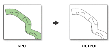
1. TOOL:
DEFINITION:
SYNTAX:

2. TOOL:
DEFINITION:
SYNTAX:
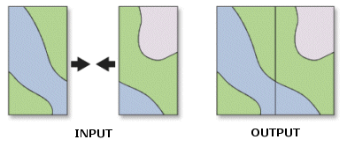
3. TOOL:
DEFINITION:
SYNTAX:
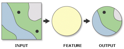
4. TOOL:
DEFINITION:
SYNTAX:
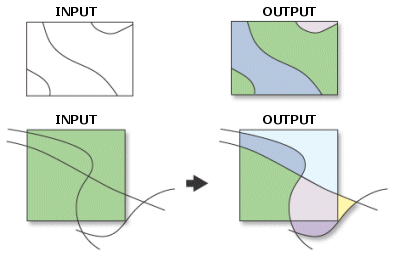
5. TOOL:
DEFINITION:
SYNTAX:
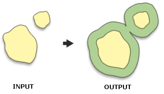
6. TOOL:
DEFINITION:
SYNTAX:
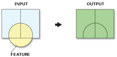
7. TOOL:
DEFINITION:
SYNTAX:
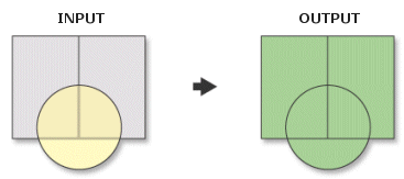
8. TOOL:
DEFINITION:
SYNTAX:
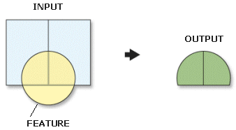
9. TOOL:
DEFINITION:
SYNTAX:
10. TOOL:
DEFINITION:
SYNTAX:
Be sure to save your work in a Word document prior to completing this form in the event that your submission is lost in transit.

8800 Grossmont College Drive
El Cajon, California 92020
619-644-7000
Accessibility
Social Media Accounts